
Inicio / OHM Vallée du Rhône / Archives cartographiques et topographiques /
Map/Long profile (Vernaison, 1848)
261/350
)
)
)
)
)
)
)
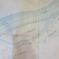
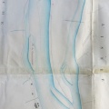
: Travaux de défense de l'Ile de la Table Ronde, dans la commune de Vernaison. English title: Defence works on the Table Ronde island in the town of Vernaison.")
Original title (in French): Travaux de défense de l'Ile de la Table Ronde, dans la commune de Vernaison. English title: Defence works on the Table Ronde island in the town of Vernaison.
- Autor
- Josserand
- Tags
- Fonds/Photographic fund
- Archives Départementales du Rhône (reference: S 1337)
- Contributeurs/Contributors
- Nature de la ressource/Resource type
- Map/Long profile
- Date
- Période/Period
- 1848
- Commune/Municipality
- Secteur/Sector
- Vernaison (2 km long)
- Echelle/Scale
- 1/2500
- Lieu visé ou point de visée/Targeted place or photographer geolocation
- Projet OHM/OHM project
- Complément d'information/Additional information
- Ressource liée/Linked resource
- DOI
- Copyright
- Creative Commons (BY-NC)