
223/350
)
)
)
)
)
)
)
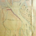
: Projet d'endiguement du Rhône dans la partie comprise entre la ville de Givors et la tête de la digue de Ste Colombe (...). English title: Embankment project for the Rhône river between the town of Givors and the head of the Ste Colombe dyke (...).")
Original title (in French): Projet d'endiguement du Rhône dans la partie comprise entre la ville de Givors et la tête de la digue de Ste Colombe (...). English title: Embankment project for the Rhône river between the town of Givors and the head of the Ste Colombe dyke (...).
- Autor
- Josserand
- Tags
- Fonds/Photographic fund
- Archives Départementales du Rhône (reference: S 1337)
- Contributeurs/Contributors
- Nature de la ressource/Resource type
- Map
- Date
- Période/Period
- 1844
- Commune/Municipality
- Secteur/Sector
- Givors (6,5 km long)
- Echelle/Scale
- 1/2500
- Lieu visé ou point de visée/Targeted place or photographer geolocation
- Projet OHM/OHM project
- Complément d'information/Additional information
- Photos of the upstream and downstream ends
- Ressource liée/Linked resource
- DOI
- Copyright
- Creative Commons (BY-NC)
- Make
- Canon
- Model
- Canon PowerShot S110
- DateTimeOriginal
- 2020:01:16 11:47:35
- ApertureFNumber
- f/2.0