
Home / OHM Vallée du Rhône / Archives cartographiques et topographiques /
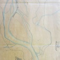
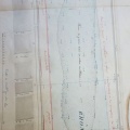
Map (St-Pierre-de-Buf to Sablons, 1846)
80/350
)
)
)
)
)
)
)
: Projet d'amélioration du cours du Rhône entre la digue des Dames et le village de Sablons sur une longueur totale de 9485 m. English title: Rhône river improvement project between the Dames dyke and the village of Sablons over a length of 9485 m.")
Original title (in French): Projet d'amélioration du cours du Rhône entre la digue des Dames et le village de Sablons sur une longueur totale de 9485 m. English title: Rhône river improvement project between the Dames dyke and the village of Sablons over a length of 9485 m.
- Author
- Josserand
- Tags
- Fonds/Photographic fund
- Archives Départementales du Rhône (reference: S 1340)
- Contributeurs/Contributors
- Nature de la ressource/Resource type
- Map
- Date
- Période/Period
- 1846
- Commune/Municipality
- Secteur/Sector
- St-Pierre-de-Buf to Sablons (10,5 km long)
- Echelle/Scale
- 1/5000
- Lieu visé ou point de visée/Targeted place or photographer geolocation
- Projet OHM/OHM project
- Complément d'information/Additional information
- Ressource liée/Linked resource
- DOI
- Copyright
- Creative Commons (BY-NC)
- Make
- Canon
- Model
- Canon PowerShot S110
- DateTimeOriginal
- 2020:01:16 12:05:50
- ApertureFNumber
- f/2.0