
330/350
)
)
)
)
)
)
)
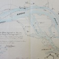
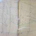
: Plan des parcelles à acquérir à la commune de Miribel pour l'amélioration du Rhône, entre le village de Thil et l'entrée de la ville de Lyon. English title: Plan of the parcels to be acquired from the town of Miribel to improve the Rhône river between Thil and the entrance to Lyon.")
Original title (in French): Plan des parcelles à acquérir à la commune de Miribel pour l'amélioration du Rhône, entre le village de Thil et l'entrée de la ville de Lyon. English title: Plan of the parcels to be acquired from the town of Miribel to improve the Rhône river between Thil and the entrance to Lyon.
- Autor
- Thiollière
- Tags
- Fonds/Photographic fund
- Archives Départementales du Rhône (reference: S 1364)
- Contributeurs/Contributors
- Nature de la ressource/Resource type
- Map
- Date
- Période/Period
- 1850
- Commune/Municipality
- Secteur/Sector
- Miribel (4,5 km long)
- Echelle/Scale
- 1/2000
- Lieu visé ou point de visée/Targeted place or photographer geolocation
- Projet OHM/OHM project
- Complément d'information/Additional information
- Tracing paper
- Ressource liée/Linked resource
- DOI
- Copyright
- Creative Commons (BY-NC)
- Make
- Canon
- Model
- Canon PowerShot S110
- DateTimeOriginal
- 2020:01:24 15:50:09
- ApertureFNumber
- f/2.0