
Accueil / OHM Vallée du Rhône / Archives cartographiques et topographiques /
Map/Cross section (Thil, 1849)
28/350
)
)
)
)
)
)
)
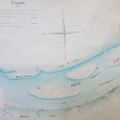
: Plan du bras de Thil et des atterissements déposés. English title: Plan of the Thil arm and deposits.")
Original title (in French): Plan du bras de Thil et des atterissements déposés. English title: Plan of the Thil arm and deposits.
- Auteur
- Thiollière
- Tags
- Fonds/Photographic fund
- Archives Départementales du Rhône (reference: S 1364)
- Contributeurs/Contributors
- Nature de la ressource/Resource type
- Map/Cross section
- Date
- Période/Period
- 1849
- Commune/Municipality
- Secteur/Sector
- Thil (2 km long)
- Echelle/Scale
- 1/1000
- Lieu visé ou point de visée/Targeted place or photographer geolocation
- Projet OHM/OHM project
- Complément d'information/Additional information
- Tracing paper
- Ressource liée/Linked resource
- DOI
- Copyright
- Creative Commons (BY-NC)
- Make
- Canon
- Model
- Canon PowerShot S110
- DateTimeOriginal
- 2020:01:24 15:47:55
- ApertureFNumber
- f/2.2