
Início / OHM Vallée du Rhône / Archives cartographiques et topographiques /
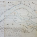
Map (Etoile-sur-Rhône to La Voulte, 1843)
114/350
)
)
)
)
)
)
)
: Plan d'une partie du cours du Rhône à l'appui des observations présentées au sujet des travaux à exécuter d'urgence en amont du domaine de Géton, sur la rive gauche de ce fleuve, en face de La Voulte. English title: Plan of part of the Rhône river in support of the observations on the urgent work to be carried out upstream of the Domaine de Géton, on the left bank opposite La Voulte.")
Original title (in French): Plan d'une partie du cours du Rhône à l'appui des observations présentées au sujet des travaux à exécuter d'urgence en amont du domaine de Géton, sur la rive gauche de ce fleuve, en face de La Voulte. English title: Plan of part of the Rhône river in support of the observations on the urgent work to be carried out upstream of the Domaine de Géton, on the left bank opposite La Voulte.
- Autor
- Josserand
- Tags
- Fonds/Photographic fund
- Archives Départementales du Rhône (reference: S 1396)
- Contributeurs/Contributors
- Nature de la ressource/Resource type
- Map
- Date
- Période/Period
- 1843
- Commune/Municipality
- Secteur/Sector
- Etoile-sur-Rhône to La Voulte (9 km long)
- Echelle/Scale
- 1/10 000
- Lieu visé ou point de visée/Targeted place or photographer geolocation
- Projet OHM/OHM project
- Complément d'information/Additional information
- 2 maps
- Ressource liée/Linked resource
- DOI
- Copyright
- Creative Commons (BY-NC)