
Accueil / OHM Vallée du Rhône / Archives cartographiques et topographiques /
Map (Tarascon to the sea, 18th c.)
23/350
)
)
)
)
)
)
)
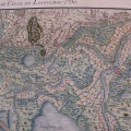
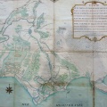
: Carte du cours du Rhône depuis Tarascon jusqu'à la mer. English title: Map of the Rhône river from Tarascon to the sea.")
Original title (in French): Carte du cours du Rhône depuis Tarascon jusqu'à la mer. English title: Map of the Rhône river from Tarascon to the sea.
- Auteur
- NA
- Tags
- Fonds/Photographic fund
- Archives Nationales (France) (reference: CP/F/14/10086/A/piece1)
- Contributeurs/Contributors
- Nature de la ressource/Resource type
- Map
- Date
- Période/Period
- 18th c.
- Commune/Municipality
- Secteur/Sector
- Tarascon to the sea (66 km long)
- Echelle/Scale
- 2500 toises
- Lieu visé ou point de visée/Targeted place or photographer geolocation
- Projet OHM/OHM project
- Complément d'information/Additional information
- Ressource liée/Linked resource
- DOI
- Copyright
- Creative Commons (BY-NC)
- Make
- Canon
- Model
- Canon PowerShot G9
- DateTimeOriginal
- 2018:07:23 03:28:24
- ApertureFNumber
- f/2.8