
Accueil / OHM Vallée du Rhône / Archives cartographiques et topographiques /
Map (Beaucaire to the sea, 18th c.)
24/350
)
)
)
)
)
)
)
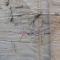
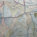
: Carte d'une partie du cours du Rosne depuis Beaucaire jusqu'à la mer sur laquelle se trouve le port de Bouc, le Martigue, le canal de Villars et toutes les isles et les terres appartenant à Monseigneur le Maréchal Duc de Villars (...). English title: Map of a part of the Rhône river from Beaucaire to the sea, on which can be found the Bouc port, the Martigue, the Villars canal, and all the islands and territories belonging to Monsignor the Marshal Duke of Villars (...).")
Original title (in French): Carte d'une partie du cours du Rosne depuis Beaucaire jusqu'à la mer sur laquelle se trouve le port de Bouc, le Martigue, le canal de Villars et toutes les isles et les terres appartenant à Monseigneur le Maréchal Duc de Villars (...). English title: Map of a part of the Rhône river from Beaucaire to the sea, on which can be found the Bouc port, the Martigue, the Villars canal, and all the islands and territories belonging to Monsignor the Marshal Duke of Villars (...).
- Auteur
- NA
- Tags
- Fonds/Photographic fund
- Archives Nationales (France) (reference: CP/F/14/10074/1/A/piece2)
- Contributeurs/Contributors
- Nature de la ressource/Resource type
- Map
- Date
- Période/Period
- 18th c.
- Commune/Municipality
- Secteur/Sector
- Beaucaire to the sea (66 km long)
- Echelle/Scale
- 6000 toises
- Lieu visé ou point de visée/Targeted place or photographer geolocation
- Projet OHM/OHM project
- Complément d'information/Additional information
- Ressource liée/Linked resource
- DOI
- Copyright
- Creative Commons (BY-NC)