
Accueil / OHM Vallée du Rhône / Archives cartographiques et topographiques /
Map (Bourg-St-Andéol, 1808)
187/350
)
)
)
)
)
)
)
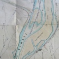
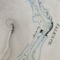
: Copie du plan d'une portion de l'île de la commune de Bourg-St-Andéol ainsi que domaine du Chaylar, appartennant à Monsieur de Chauras, levé lors des basses eaux du Rhône. English title: Copy of the plan of a portion of the island in the town of Bourg-St-Andéol, as well as the Chaylar estate, belonging to Mr. De Chauras, surveyed at low-flow.")
Original title (in French): Copie du plan d'une portion de l'île de la commune de Bourg-St-Andéol ainsi que domaine du Chaylar, appartennant à Monsieur de Chauras, levé lors des basses eaux du Rhône. English title: Copy of the plan of a portion of the island in the town of Bourg-St-Andéol, as well as the Chaylar estate, belonging to Mr. De Chauras, surveyed at low-flow.
- Auteur
- Vivien
- Tags
- Fonds/Photographic fund
- Archives Nationales (France) (reference: CP/F/14/10074/1/A/piece19)
- Contributeurs/Contributors
- Nature de la ressource/Resource type
- Map
- Date
- Période/Period
- 1808
- Commune/Municipality
- Secteur/Sector
- Bourg-St-Andéol (1 km long)
- Echelle/Scale
- ~ 1/1500
- Lieu visé ou point de visée/Targeted place or photographer geolocation
- Projet OHM/OHM project
- Complément d'information/Additional information
- Ressource liée/Linked resource
- DOI
- Copyright
- Creative Commons (BY-NC)