
186/350
)
)
)
)
)
)
)
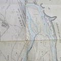
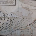
: Plan du cours du Rhône dans l'intervalle du village du Pouzin à celui de Baix, pour servir au projet de défense du territoire de ces deux communes. English title: Map of the Rhône river between the towns of Pouzin and Baix, to be used for the project to defend these two towns.")
Original title (in French): Plan du cours du Rhône dans l'intervalle du village du Pouzin à celui de Baix, pour servir au projet de défense du territoire de ces deux communes. English title: Map of the Rhône river between the towns of Pouzin and Baix, to be used for the project to defend these two towns.
- Auteur
- Lagniol
- Tags
- Fonds/Photographic fund
- Archives Nationales (France) (reference: CP/F/14/10074/1/A/piece18)
- Contributeurs/Contributors
- Nature de la ressource/Resource type
- Map
- Date
- Période/Period
- 1807
- Commune/Municipality
- Secteur/Sector
- Le Pouzin (5 km long)
- Echelle/Scale
- ~ 1/5000
- Lieu visé ou point de visée/Targeted place or photographer geolocation
- Projet OHM/OHM project
- Complément d'information/Additional information
- Ressource liée/Linked resource
- DOI
- Copyright
- Creative Commons (BY-NC)