
182/350
)
)
)
)
)
)
)
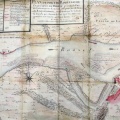
: Plan des bords du Rhône et des atterissements qui se sont formés dans son lit depuis la ville de Beaucaire jusqu'à l'île de Vallabrègues (...). English title: Map of the Rhône banks and deposits that formed in its bed from the city of Beaucaire to the Vallabrègues island (...) .")
Original title (in French): Plan des bords du Rhône et des atterissements qui se sont formés dans son lit depuis la ville de Beaucaire jusqu'à l'île de Vallabrègues (...). English title: Map of the Rhône banks and deposits that formed in its bed from the city of Beaucaire to the Vallabrègues island (...) .
- Auteur
- Grangent
- Tags
- Fonds/Photographic fund
- Archives Nationales (France) (reference: CP/F/14/10074/2/piece3)
- Contributeurs/Contributors
- Nature de la ressource/Resource type
- Map
- Date
- Période/Period
- 1792
- Commune/Municipality
- Secteur/Sector
- Beaucaire (2 km long)
- Echelle/Scale
- 160 toises / 300 m
- Lieu visé ou point de visée/Targeted place or photographer geolocation
- Projet OHM/OHM project
- Complément d'information/Additional information
- Ressource liée/Linked resource
- DOI
- Copyright
- Creative Commons (BY-NC)