
181/350
)
)
)
)
)
)
)
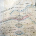
: Plan du port de Roquemaure et du cours du Rhône pris au-dessus de la métairie d'Auriac jusqu'au-dessous de Roquemaure (...). English title: Map of the port of Roquemaure and the Rhône river surveyed above the Auriac farm to below Roquemaure (...).")
Original title (in French): Plan du port de Roquemaure et du cours du Rhône pris au-dessus de la métairie d'Auriac jusqu'au-dessous de Roquemaure (...). English title: Map of the port of Roquemaure and the Rhône river surveyed above the Auriac farm to below Roquemaure (...).
- Auteur
- Delisle & Grangent
- Tags
- Fonds/Photographic fund
- Archives Nationales (France) (reference: CP/F/14/10074/1/A/piece7)
- Contributeurs/Contributors
- Nature de la ressource/Resource type
- Map
- Date
- Période/Period
- 1789
- Commune/Municipality
- Secteur/Sector
- Roquemaure (5,5 km long)
- Echelle/Scale
- 100 toises / 800 m
- Lieu visé ou point de visée/Targeted place or photographer geolocation
- Projet OHM/OHM project
- Complément d'information/Additional information
- Ressource liée/Linked resource
- DOI
- Copyright
- Creative Commons (BY-NC)