
Início / OHM Vallée du Rhône / Archives cartographiques et topographiques /
Map (La Voulte to Le Pouzin, 1851-1852)
136/350
)
)
)
)
)
)
)
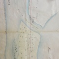
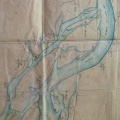
: Construction du barrage du bras de la Poule. English title: Construction of the Poule Channel dam.")
Original title (in French): Construction du barrage du bras de la Poule. English title: Construction of the Poule Channel dam.
- Autor
- Goux
- Tags
- Fonds/Photographic fund
- Archives Nationales (France), Archives Départementales du Rhône (reference: F/14/6517, S 1410)
- Contributeurs/Contributors
- Nature de la ressource/Resource type
- Map
- Date
- Période/Period
- 1851-1852
- Commune/Municipality
- Secteur/Sector
- La Voulte to Le Pouzin (9 km long)
- Echelle/Scale
- 1/10 000
- Lieu visé ou point de visée/Targeted place or photographer geolocation
- Projet OHM/OHM project
- Complément d'information/Additional information
- 2 maps
- Ressource liée/Linked resource
- DOI
- Copyright
- Creative Commons (BY-NC)