
Início / OHM Vallée du Rhône / Archives cartographiques et topographiques /
Map (La Voulte to Drôme confluence, 1850)
172/350
)
)
)
)
)
)
)
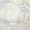
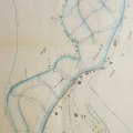
: Projet des ouvrages à faire pour prolonger le barrage de Géton jusqu'à l'embouchure de la Drôme désignés sous le nom de digue des Pommiers. English title: Project to extend the Géton dam to the mouth of the Drôme River, known as the Pommiers dyke.")
Original title (in French): Projet des ouvrages à faire pour prolonger le barrage de Géton jusqu'à l'embouchure de la Drôme désignés sous le nom de digue des Pommiers. English title: Project to extend the Géton dam to the mouth of the Drôme River, known as the Pommiers dyke.
- Autor
- Goux
- Tags
- Fonds/Photographic fund
- Archives Départementales du Rhône (reference: S 1397)
- Contributeurs/Contributors
- Nature de la ressource/Resource type
- Map
- Date
- Période/Period
- 1850
- Commune/Municipality
- Secteur/Sector
- La Voulte to Drôme confluence (4 km long)
- Echelle/Scale
- 1/2500
- Lieu visé ou point de visée/Targeted place or photographer geolocation
- Projet OHM/OHM project
- Complément d'information/Additional information
- Ressource liée/Linked resource
- DOI
- Copyright
- Creative Commons (BY-NC)