
271/350
)
)
)
)
)
)
)
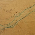
: Plan d'une partie du cours du Rhône à l'appui du rapport sur la réclamation présentée par Mr. Ducros propriétaire à Baix. English title: Plan of part of the Rhône river in support of the report on the claim presented by Mr. Ducros, owner at Baix.")
Original title (in French): Plan d'une partie du cours du Rhône à l'appui du rapport sur la réclamation présentée par Mr. Ducros propriétaire à Baix. English title: Plan of part of the Rhône river in support of the report on the claim presented by Mr. Ducros, owner at Baix.

- Autor
- Josserand
- Tags
- Fonds/Photographic fund
- Archives Départementales du Rhône (reference: S 1410, S 1397)
- Contributeurs/Contributors
- Nature de la ressource/Resource type
- Map
- Date
- Période/Period
- 1846
- Commune/Municipality
- Secteur/Sector
- Baix (9 km long)
- Echelle/Scale
- 1/10 000
- Lieu visé ou point de visée/Targeted place or photographer geolocation
- Projet OHM/OHM project
- Complément d'information/Additional information
- Tracing paper. 2 maps
- Ressource liée/Linked resource
- DOI
- Copyright
- Creative Commons (BY-NC)
- Make
- Canon
- Model
- Canon PowerShot S110
- DateTimeOriginal
- 2020:01:30 15:19:36
- ApertureFNumber
- f/2.0