
279/350
)
)
)
)
)
)
)
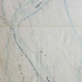
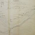
: Extrait du plan général du cours du Rhône à l'appui du projet des ouvrages à faire pour terminer complètement la digue en construction sur le territoire de Beauchastel, rive droite du Rhône, et la prolonger de 313 m en aval. English title: Extract from the general plan of the Rhône river in support of the project of the works to be done to complete the dyke construction at Beauchastel, right bank of the Rhône, and extend it by 313 m downstream.")
Original title (in French): Extrait du plan général du cours du Rhône à l'appui du projet des ouvrages à faire pour terminer complètement la digue en construction sur le territoire de Beauchastel, rive droite du Rhône, et la prolonger de 313 m en aval. English title: Extract from the general plan of the Rhône river in support of the project of the works to be done to complete the dyke construction at Beauchastel, right bank of the Rhône, and extend it by 313 m downstream.
- Author
- Josserand
- Tags
- Fonds/Photographic fund
- Archives Départementales du Rhône (reference: S 1410)
- Contributeurs/Contributors
- Nature de la ressource/Resource type
- Map
- Date
- Période/Period
- 1844
- Commune/Municipality
- Secteur/Sector
- Beauchastel (5 km long)
- Echelle/Scale
- 1/10 000
- Lieu visé ou point de visée/Targeted place or photographer geolocation
- Projet OHM/OHM project
- Complément d'information/Additional information
- Tracing paper
- Ressource liée/Linked resource
- DOI
- Copyright
- Creative Commons (BY-NC)
- Make
- Canon
- Model
- Canon PowerShot S110
- DateTimeOriginal
- 2020:01:30 15:21:56
- ApertureFNumber
- f/2.0