
280/350
)
)
)
)
)
)
)
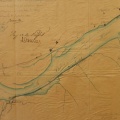
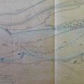
: Extrait du plan général du cours du Rhône pour servir à connaitre l'emplacement de la nouvelle digue que l'on propose de construire dans la commune de Beauchastel. English title: Extract from the general plan of the Rhône river to be used to locate the proposed new dyke that is to be built in the town of Beauchastel.")
Original title (in French): Extrait du plan général du cours du Rhône pour servir à connaitre l'emplacement de la nouvelle digue que l'on propose de construire dans la commune de Beauchastel. English title: Extract from the general plan of the Rhône river to be used to locate the proposed new dyke that is to be built in the town of Beauchastel.
- Author
- Ponts & Chaussées
- Tags
- Fonds/Photographic fund
- Archives Départementales du Rhône (reference: S 1410)
- Contributeurs/Contributors
- Nature de la ressource/Resource type
- Map
- Date
- Période/Period
- 1841
- Commune/Municipality
- Secteur/Sector
- Beauchastel (5,5 km long)
- Echelle/Scale
- 1/10 000
- Lieu visé ou point de visée/Targeted place or photographer geolocation
- Projet OHM/OHM project
- Complément d'information/Additional information
- Ressource liée/Linked resource
- DOI
- Copyright
- Creative Commons (BY-NC)
- Make
- Canon
- Model
- Canon PowerShot S110
- DateTimeOriginal
- 2020:01:30 15:21:04
- ApertureFNumber
- f/2.0