
101/350
)
)
)
)
)
)
)
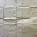
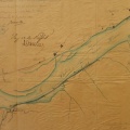
: Endiguement du Rhône sur le territoire de la commune d'Oullins sur une longueur de 1750 m. English title: Impoundment of the Rhône river at Oullins over a length of 1750 m.")
Original title (in French): Endiguement du Rhône sur le territoire de la commune d'Oullins sur une longueur de 1750 m. English title: Impoundment of the Rhône river at Oullins over a length of 1750 m.
- Author
- Josserand
- Tags
- Fonds/Photographic fund
- Archives Départementales du Rhône (reference: S 1363)
- Contributeurs/Contributors
- Nature de la ressource/Resource type
- Map
- Date
- Période/Period
- 1847
- Commune/Municipality
- Secteur/Sector
- Pierre-Benite (5 km long)
- Echelle/Scale
- 1/5000
- Lieu visé ou point de visée/Targeted place or photographer geolocation
- Projet OHM/OHM project
- Complément d'information/Additional information
- Ressource liée/Linked resource
- DOI
- Copyright
- Creative Commons (BY-NC)
- Make
- Canon
- Model
- Canon PowerShot S110
- DateTimeOriginal
- 2020:01:24 14:18:02
- ApertureFNumber
- f/2.2