
97/350
)
)
)
)
)
)
)
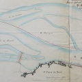
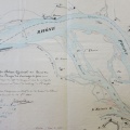
: Projet d'amélioration de la navigation du Rhône en amont du pont suspendu de Valence. English title: Project to improve navigation of the Rhône river upstream of the Valence suspension bridge.")
Original title (in French): Projet d'amélioration de la navigation du Rhône en amont du pont suspendu de Valence. English title: Project to improve navigation of the Rhône river upstream of the Valence suspension bridge.
- Autor
- Josserand
- Tags
- Fonds/Photographic fund
- Archives Départementales du Rhône (reference: S 1396)
- Contributeurs/Contributors
- Nature de la ressource/Resource type
- Map
- Date
- Période/Period
- 1845
- Commune/Municipality
- Secteur/Sector
- Valence (4 km long)
- Echelle/Scale
- 1/2500
- Lieu visé ou point de visée/Targeted place or photographer geolocation
- Projet OHM/OHM project
- Complément d'information/Additional information
- Ressource liée/Linked resource
- DOI
- Copyright
- Creative Commons (BY-NC)