
Home / OHM Vallée du Rhône / Archives cartographiques et topographiques /
Map/Cross section (Chavanay, 1851)
290/350
)
)
)
)
)
)
)
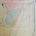
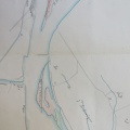
: Projet d'endiguement du Rhône sur le territoire des communes de Chavanay et de St-Pierre-de-Buf en prolongement de la digue de Chavanay sur une longueur de 1650 m. English title: Embankment project for the Rhône river in the towns of Chavanay and St-Pierre-de-Buf, as an extension of the Chavanay dyke over a length of 1650 m.")
Original title (in French): Projet d'endiguement du Rhône sur le territoire des communes de Chavanay et de St-Pierre-de-Buf en prolongement de la digue de Chavanay sur une longueur de 1650 m. English title: Embankment project for the Rhône river in the towns of Chavanay and St-Pierre-de-Buf, as an extension of the Chavanay dyke over a length of 1650 m.
- Author
- Goux
- Tags
- Fonds/Photographic fund
- Archives Départementales du Rhône (reference: S 1393)
- Contributeurs/Contributors
- Nature de la ressource/Resource type
- Map/Cross section
- Date
- Période/Period
- 1851
- Commune/Municipality
- Secteur/Sector
- Chavanay (5 km long)
- Echelle/Scale
- 1/5000
- Lieu visé ou point de visée/Targeted place or photographer geolocation
- Projet OHM/OHM project
- Complément d'information/Additional information
- Plan and 3 cross sections
- Ressource liée/Linked resource
- DOI
- Copyright
- Creative Commons (BY-NC)
- Make
- Canon
- Model
- Canon PowerShot S110
- DateTimeOriginal
- 2020:01:24 13:55:00
- ApertureFNumber
- f/2.0