
85/350
)
)
)
)
)
)
)
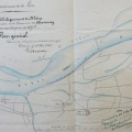
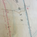
: Plan de la plaine de Chavanay indiquant les différentes classes de terrains appelés à contribuer à la construction de cette digue. English title: Plan of the Chavanay plain showing the different classes of land that will contribute to the construction of this dyke.")
Original title (in French): Plan de la plaine de Chavanay indiquant les différentes classes de terrains appelés à contribuer à la construction de cette digue. English title: Plan of the Chavanay plain showing the different classes of land that will contribute to the construction of this dyke.
- Autor
- Goux
- Tags
- Fonds/Photographic fund
- Archives Départementales du Rhône (reference: S 1393)
- Contributeurs/Contributors
- Nature de la ressource/Resource type
- Map
- Date
- Période/Period
- 1850
- Commune/Municipality
- Secteur/Sector
- Chavanay (4,5 km long)
- Echelle/Scale
- 1/5000
- Lieu visé ou point de visée/Targeted place or photographer geolocation
- Projet OHM/OHM project
- Complément d'information/Additional information
- Ressource liée/Linked resource
- DOI
- Copyright
- Creative Commons (BY-NC)
- Make
- Canon
- Model
- Canon PowerShot S110
- DateTimeOriginal
- 2020:01:24 13:53:21
- ApertureFNumber
- f/2.0