
Inicio / OHM Vallée du Rhône / Archives cartographiques et topographiques /
Map/Cross section (Aramon to Vallabrègues, 1847)
293/350
)
)
)
)
)
)
)
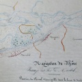
: Projet d'un revêtement de rive sur l'Ilette, en face de Vallabrègues, sur une longueur de 1139,80 m. English title: Project of a bank lining on the Ilette island, opposite Vallabrègues, over a length of 1139.80 m.")
Original title (in French): Projet d'un revêtement de rive sur l'Ilette, en face de Vallabrègues, sur une longueur de 1139,80 m. English title: Project of a bank lining on the Ilette island, opposite Vallabrègues, over a length of 1139.80 m.
- Autor
- Surell
- Tags
- Fonds/Photographic fund
- Archives Départementales du Rhône (reference: S 1348)
- Contributeurs/Contributors
- Nature de la ressource/Resource type
- Map/Cross section
- Date
- Période/Period
- 1847
- Commune/Municipality
- Secteur/Sector
- Aramon to Vallabrègues (10 km long)
- Echelle/Scale
- 1/10 000
- Lieu visé ou point de visée/Targeted place or photographer geolocation
- Projet OHM/OHM project
- Complément d'information/Additional information
- 1 map, cross sections n°18 to 32
- Ressource liée/Linked resource
- DOI
- Copyright
- Creative Commons (BY-NC)