
Accueil / OHM Vallée du Rhône / Archives cartographiques et topographiques /
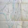
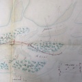
Map (Jonage to Rillieux-la-Pape, 1845)
192/350
)
)
)
)
)
)
)
: Fixation du chenal navigable dans le bras de droite. English title: Fixation of the navigable channel in the right arm.")
Original title (in French): Fixation du chenal navigable dans le bras de droite. English title: Fixation of the navigable channel in the right arm.
- Auteur
- O'Brien
- Tags
- Fonds/Photographic fund
- Archives Départementales du Rhône (reference: S 1357)
- Contributeurs/Contributors
- Nature de la ressource/Resource type
- Map
- Date
- Période/Period
- 1845
- Commune/Municipality
- Secteur/Sector
- Jonage to Rillieux-la-Pape (17 km long)
- Echelle/Scale
- 1/40 000
- Lieu visé ou point de visée/Targeted place or photographer geolocation
- Projet OHM/OHM project
- Complément d'information/Additional information
- Ressource liée/Linked resource
- DOI
- Copyright
- Creative Commons (BY-NC)