
Home / OHM Vallée du Rhône / Archives cartographiques et topographiques /
Map/Long profile (St-Clair-du-Rhône to Sablons, 1842)
9/350
)
)
)
)
)
)
)
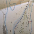
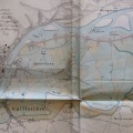
: Construction d'une digue en terre revêtue de perrés destinée à servir de chemin de halage le long de la rive gauche du Rhône entre le bac des Dames et le pont suspendu de Sablons. English title: Construction of an earthen dyke covered with riprap for use as a towpath along the left bank of the Rhône river between the Dames ferry and the Sablons suspension bridge.")
Original title (in French): Construction d'une digue en terre revêtue de perrés destinée à servir de chemin de halage le long de la rive gauche du Rhône entre le bac des Dames et le pont suspendu de Sablons. English title: Construction of an earthen dyke covered with riprap for use as a towpath along the left bank of the Rhône river between the Dames ferry and the Sablons suspension bridge.
- Author
- Berthier
- Tags
- Fonds/Photographic fund
- Archives Départementales du Rhône (reference: S 1340)
- Contributeurs/Contributors
- Nature de la ressource/Resource type
- Map/Long profile
- Date
- Période/Period
- 1842
- Commune/Municipality
- Secteur/Sector
- St-Clair-du-Rhône to Sablons (17,5 km long)
- Echelle/Scale
- 1/10 000
- Lieu visé ou point de visée/Targeted place or photographer geolocation
- Projet OHM/OHM project
- Complément d'information/Additional information
- 1 map and 1 long profile
- Ressource liée/Linked resource
- DOI
- Copyright
- Creative Commons (BY-NC)
- Make
- Canon
- Model
- Canon PowerShot S110
- DateTimeOriginal
- 2020:01:16 12:09:37
- ApertureFNumber
- f/2.0