
Accueil / OHM Vallée du Rhône / Archives cartographiques et topographiques /
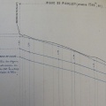
Map/Long profile (Jons to Pierre-Bénite, 1837)
71/350
)
)
)
)
)
)
)
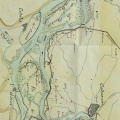
: Plan général et projet de la digue à construire contre les plus hautes eaux du Rhône, à partir de la Tête d'Or aux Brotteaux et en remontant le fleuve jusqu'à la limite des communes de Jons et de Jonage sur une longueur de 19300,98 m . English title: General plan and project for the dyke to be built against the highest floods of the Rhône river, starting at the Tête d'Or, Brotteaux and going up the river to the limit of the towns of Jons and Jonage over a length of 19300.98 m .")
Original title (in French): Plan général et projet de la digue à construire contre les plus hautes eaux du Rhône, à partir de la Tête d'Or aux Brotteaux et en remontant le fleuve jusqu'à la limite des communes de Jons et de Jonage sur une longueur de 19300,98 m . English title: General plan and project for the dyke to be built against the highest floods of the Rhône river, starting at the Tête d'Or, Brotteaux and going up the river to the limit of the towns of Jons and Jonage over a length of 19300.98 m .
- Auteur
- Dignoscyo
- Tags
- Fonds/Photographic fund
- Archives Nationales (France) (reference: CP/F/14/10074/2/pieces5-7)
- Contributeurs/Contributors
- Nature de la ressource/Resource type
- Map/Long profile
- Date
- Période/Period
- 1837
- Commune/Municipality
- Secteur/Sector
- Jons to Pierre-Bénite (30 km long)
- Echelle/Scale
- 1/10 000
- Lieu visé ou point de visée/Targeted place or photographer geolocation
- Projet OHM/OHM project
- Complément d'information/Additional information
- 1 map and 1 long profile (19 km)
- Ressource liée/Linked resource
- DOI
- Copyright
- Creative Commons (BY-NC)