
Accueil / OHM Vallée du Rhône / Archives cartographiques et topographiques /
Map/Cross section (Lyon, 1846-1850)
290/350
)
)
)
)
)
)
)
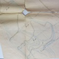
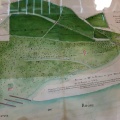
: Projet de quais et de bas-ports sur la rive gauche du Rhône. English title: Project for quays and low ports on the left bank of the Rhône river.")
Original title (in French): Projet de quais et de bas-ports sur la rive gauche du Rhône. English title: Project for quays and low ports on the left bank of the Rhône river.
- Auteur
- Menard
- Tags
- Fonds/Photographic fund
- Archives Départementales du Rhône (reference: S 1337)
- Contributeurs/Contributors
- Nature de la ressource/Resource type
- Map/Cross section
- Date
- Période/Period
- 1846-1850
- Commune/Municipality
- Secteur/Sector
- Lyon (3,5 km long)
- Echelle/Scale
- 1/2000
- Lieu visé ou point de visée/Targeted place or photographer geolocation
- Projet OHM/OHM project
- Complément d'information/Additional information
- Ressource liée/Linked resource
- DOI
- Copyright
- Creative Commons (BY-NC)
- Make
- Canon
- Model
- Canon PowerShot S110
- DateTimeOriginal
- 2020:01:16 11:37:11
- ApertureFNumber
- f/2.0