
1156/1165
)
)
)
)
)
)
)
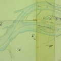
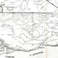
: Défense de la plaine et du village de Glun contre les inondations. English title: Defence of the Glun plain and village against floods.")
Original title (in French): Défense de la plaine et du village de Glun contre les inondations. English title: Defence of the Glun plain and village against floods.
- Author
- Kleitz
- Tags
- Fonds/Photographic fund
- Archives Départementales du Rhône (reference: S 1412)
- Contributeurs/Contributors
- Nature de la ressource/Resource type
- Map
- Date
- Période/Period
- 1860
- Commune/Municipality
- Secteur/Sector
- Glun (4 km long)
- Echelle/Scale
- 1/5000
- Lieu visé ou point de visée/Targeted place or photographer geolocation
- Projet OHM/OHM project
- Complément d'information/Additional information
- Ressource liée/Linked resource
- DOI
- Copyright
- Creative Commons (BY-NC)