
801/1165
)
)
)
)
)
)
)
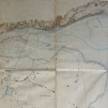
: Plan général à l'appui du projet des ouvrages à faire pour la construction d'un barrage à établir à la suite de la digue en prolongement de celle de Chateauneuf. English title: Plan in support of the project of the works to be carried out for the construction of a dam following an extension of the Châteauneuf dyke.")
Original title (in French): Plan général à l'appui du projet des ouvrages à faire pour la construction d'un barrage à établir à la suite de la digue en prolongement de celle de Chateauneuf. English title: Plan in support of the project of the works to be carried out for the construction of a dam following an extension of the Châteauneuf dyke.
- Autor
- Josserand
- Tags
- Fonds/Photographic fund
- Archives Nationales (France) (reference: F/14/6566)
- Contributeurs/Contributors
- Nature de la ressource/Resource type
- Map
- Date
- Période/Period
- 1846
- Commune/Municipality
- Secteur/Sector
- Chateauneuf (10 km long)
- Echelle/Scale
- 1/10 000
- Lieu visé ou point de visée/Targeted place or photographer geolocation
- Projet OHM/OHM project
- Complément d'information/Additional information
- Ressource liée/Linked resource
- DOI
- Copyright
- Creative Commons (BY-NC)