Bienvenue dans la photothèque du Laboratoire d'Excellence "Dispositif de Recherche Interdisciplinaire sur les Interactions Hommes-Milieux" (DRIIHM) composé de 13 Observatoires Hommes-Milieux.

Welcome to the photo library of the "Device for Interdisciplinary Research on Human-environments Interactions" (DRIIHM) Laboratory of Excellence.

[ arrêter le diaporama ]

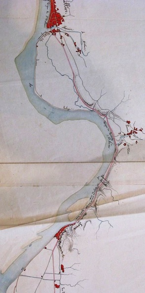
Map (St Rambert to Pont-St-Esprit, 1833)

503.jpg Map/Cross section/Long profile/Slope table (Lyon to the sea, 1822-1824)MiniaturesMap (St-Marcel-d'Ardèche to Barbentane , 1834)Map/Cross section/Long profile/Slope table (Lyon to the sea, 1822-1824)MiniaturesMap (St-Marcel-d'Ardèche to Barbentane , 1834)Map/Cross section/Long profile/Slope table (Lyon to the sea, 1822-1824)MiniaturesMap (St-Marcel-d'Ardèche to Barbentane , 1834)Map/Cross section/Long profile/Slope table (Lyon to the sea, 1822-1824)MiniaturesMap (St-Marcel-d'Ardèche to Barbentane , 1834)Map/Cross section/Long profile/Slope table (Lyon to the sea, 1822-1824)MiniaturesMap (St-Marcel-d'Ardèche to Barbentane , 1834)Map/Cross section/Long profile/Slope table (Lyon to the sea, 1822-1824)MiniaturesMap (St-Marcel-d'Ardèche to Barbentane , 1834)

Original title (in French): Plan de la partie du cours du Rhône et de la rive gauche de ce fleuve comprise dans le département de la Drôme, entre l'embouchure du ruisseau du Dolon (...) et celle du Lauzon. English title: Plan of the part of the Rhône river and the left bank of this river included in the department of the Drôme, between the Dolon confluence (...) and that of the Lauzon.