
1286/10499
)
)
)
)
)
)
)
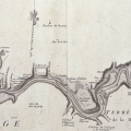
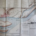
: Plan des îles du Rhône. English title: Map of the Rhône islands.")
Original title (in French): Plan des îles du Rhône. English title: Map of the Rhône islands.
- Auteur
- Grandvoinet
- Tags
- Fonds/Photographic fund
- Archives Départementales du Gard (reference: C.93, C.94)
- Contributeurs/Contributors
- Nature de la ressource/Resource type
- Map
- Date
- Période/Period
- 1781
- Commune/Municipality
- Secteur/Sector
- Limony to Bourg-St-Andéol (120 km long)
- Echelle/Scale
- 1/3600
- Lieu visé ou point de visée/Targeted place or photographer geolocation
- Projet OHM/OHM project
- Complément d'information/Additional information
- Sheets 1 to 10 and 11 to 20
- Ressource liée/Linked resource
- DOI
- Copyright
- Creative Commons (BY-NC)
- Make
- Canon
- Model
- Canon PowerShot G9
- DateTimeOriginal
- 2017:04:27 04:52:16
- ApertureFNumber
- f/3.2