
1285/10499
)
)
)
)
)
)
)
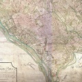
: Carte géométrique d'une partie du cours du Rhône depuis Genève jusqu'au confluent du Guyer pour servir à la nouvelle limitation des Etats de France et de Savoie. English title: Geometrical map of part of the Rhône river from Geneva to the Guyer confluence to serve as the new boundary of the States of France and Savoy.")
Original title (in French): Carte géométrique d'une partie du cours du Rhône depuis Genève jusqu'au confluent du Guyer pour servir à la nouvelle limitation des Etats de France et de Savoie. English title: Geometrical map of part of the Rhône river from Geneva to the Guyer confluence to serve as the new boundary of the States of France and Savoy.
- Auteur
- De Bourcet
- Tags
- Fonds/Photographic fund
- Archives Départementales de la Savoie (reference: 1Fi S52, 1Fi S53)
- Contributeurs/Contributors
- Nature de la ressource/Resource type
- Map
- Date
- Période/Period
- 1760
- Commune/Municipality
- Secteur/Sector
- Genève to St-Genix-sur-Guiers (106 km long)
- Echelle/Scale
- 1/28 246
- Lieu visé ou point de visée/Targeted place or photographer geolocation
- Projet OHM/OHM project
- Complément d'information/Additional information
- Lateral lines resulted from the Treaty of Turin (1760) between France and the Kingdom of Sardinia. It prohibited to build offensive dykes between the lateral lines likely to send the river back to the opposite bank
- Ressource liée/Linked resource
- DOI
- Copyright
- Creative Commons (BY-NC)