
Accueil / OHM Vallée du Rhône / Archives cartographiques et topographiques /
Map (Bourg-St-Andéol to Pont-St-Esprit, 1855)
66/350
)
)
)
)
)
)
)
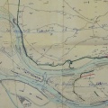
: Projet de défense de la berge de l'Ile St Etienne de Dions. English title: Project for the defence of the bank of the St-Etienne-de-Dions island.")
Original title (in French): Projet de défense de la berge de l'Ile St Etienne de Dions. English title: Project for the defence of the bank of the St-Etienne-de-Dions island.

- Auteur
- Kleitz
- Tags
- Fonds/Photographic fund
- Archives Départementales du Rhône (reference: S 1424, S 1342, S 1344)
- Contributeurs/Contributors
- Nature de la ressource/Resource type
- Map
- Date
- Période/Period
- 1855
- Commune/Municipality
- Secteur/Sector
- Bourg-St-Andéol to Pont-St-Esprit (14,5 km long)
- Echelle/Scale
- 1/10 000, 1/2500
- Lieu visé ou point de visée/Targeted place or photographer geolocation
- Projet OHM/OHM project
- Complément d'information/Additional information
- 3 general maps and 1 detailed map
- Ressource liée/Linked resource
- DOI
- Copyright
- Creative Commons (BY-NC)