
8313/10499
)
)
)
)
)
)
)
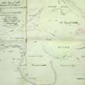
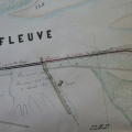
: Plan du cours du Rhône et des digues sur le territoire de St Esprit. English title: Map of the Rhône river and the dykes at St Esprit.")
Original title (in French): Plan du cours du Rhône et des digues sur le territoire de St Esprit. English title: Map of the Rhône river and the dykes at St Esprit.
- Autor
- Perrier
- Tags
- Fonds/Photographic fund
- Archives Nationales (France) (reference: F/14/6585)
- Contributeurs/Contributors
- Nature de la ressource/Resource type
- Map
- Date
- Période/Period
- 1842
- Commune/Municipality
- Secteur/Sector
- Pont-St-Esprit (8 km long)
- Echelle/Scale
- 1/10 000
- Lieu visé ou point de visée/Targeted place or photographer geolocation
- Projet OHM/OHM project
- Complément d'information/Additional information
- Ressource liée/Linked resource
- DOI
- Copyright
- Creative Commons (BY-NC)