
1335/10499
)
)
)
)
)
)
)
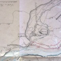
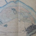
: Projet de construction d'un chemin de halage en face de la propriété de Mr. Turquis destiné à barrer la lône ouverte par la crue du 15 avril 1847 dans la plaine de Beauchamp (commune de Pont-St-Esprit). English title: Project for the construction of a towpath in front of the property of Mr. Turquis intended to block the abandoned channel opened by the flood of April 15, 1847 in the Beauchamp plain (Pont-St-Esprit).")
Original title (in French): Projet de construction d'un chemin de halage en face de la propriété de Mr. Turquis destiné à barrer la lône ouverte par la crue du 15 avril 1847 dans la plaine de Beauchamp (commune de Pont-St-Esprit). English title: Project for the construction of a towpath in front of the property of Mr. Turquis intended to block the abandoned channel opened by the flood of April 15, 1847 in the Beauchamp plain (Pont-St-Esprit).
- Auteur
- Bouvier
- Tags
- Fonds/Photographic fund
- Archives Départementales du Rhône, Archives Nationales (France) (reference: S 1432, F/14/6590)
- Contributeurs/Contributors
- Nature de la ressource/Resource type
- Map
- Date
- Période/Period
- 1847
- Commune/Municipality
- Secteur/Sector
- Pont-St-Esprit (8,5 km long)
- Echelle/Scale
- 1/10 000, 1/5000
- Lieu visé ou point de visée/Targeted place or photographer geolocation
- Projet OHM/OHM project
- Complément d'information/Additional information
- 2 maps
- Ressource liée/Linked resource
- DOI
- Copyright
- Creative Commons (BY-NC)
- Make
- Canon
- Model
- Canon PowerShot G9
- DateTimeOriginal
- 2018:12:04 15:14:22
- ApertureFNumber
- f/2.8