
102/350
)
)
)
)
)
)
)
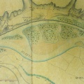
: Carte des abords du Rhône et de la plaine de Lussan depuis la chaussée de ce nom jusqu'à l'écluse de prise d'eau du canal de Beaucaire. English title: Map of the Rhône river banks and the Lussan plain from the Lussan roadway to the lock of the Beaucaire canal water intake.")
Original title (in French): Carte des abords du Rhône et de la plaine de Lussan depuis la chaussée de ce nom jusqu'à l'écluse de prise d'eau du canal de Beaucaire. English title: Map of the Rhône river banks and the Lussan plain from the Lussan roadway to the lock of the Beaucaire canal water intake.
- Autor
- Courrotz & Grangent
- Tags
- Fonds/Photographic fund
- Archives Nationales (France) (reference: CP/F/14/10074/1/A/piece24)
- Contributeurs/Contributors
- Nature de la ressource/Resource type
- Map
- Date
- Période/Period
- 1810
- Commune/Municipality
- Secteur/Sector
- Tarascon (4 km long)
- Echelle/Scale
- ~ 1/5000
- Lieu visé ou point de visée/Targeted place or photographer geolocation
- Projet OHM/OHM project
- Complément d'information/Additional information
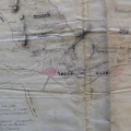
- Tracing paper
- Ressource liée/Linked resource
- DOI
- Copyright
- Creative Commons (BY-NC)