
178/350
)
)
)
)
)
)
)
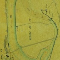
: Plan parcellaire de l'île de Lubière, terroir de Beaucaire. English title: Plan of the parcellation of Lubière island, Beaucaire terroir.")
Original title (in French): Plan parcellaire de l'île de Lubière, terroir de Beaucaire. English title: Plan of the parcellation of Lubière island, Beaucaire terroir.
- Auteur
- Durant & Grangent
- Tags
- Fonds/Photographic fund
- Archives Nationales (France) (reference: CP/F/14/10074/1/A/piece22)
- Contributeurs/Contributors
- Nature de la ressource/Resource type
- Map
- Date
- Période/Period
- 1809
- Commune/Municipality
- Secteur/Sector
- Beaucaire (1 km long)
- Echelle/Scale
- 1/2500
- Lieu visé ou point de visée/Targeted place or photographer geolocation
- Projet OHM/OHM project
- Complément d'information/Additional information
- Ressource liée/Linked resource
- DOI
- Copyright
- Creative Commons (BY-NC)