
82/350
)
)
)
)
)
)
)
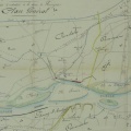
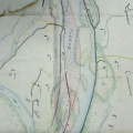
: Projet de construction d'un chemin de halage destiné à relier celui du Revestidou situé en amont du pont de Roquemaure au chemin de halage de l'Hers. English title: Project for the construction of a towpath intended to connect the Revestidou towpath, located upstream of the Roquemaure bridge, to the Hers towpath.")
Original title (in French): Projet de construction d'un chemin de halage destiné à relier celui du Revestidou situé en amont du pont de Roquemaure au chemin de halage de l'Hers. English title: Project for the construction of a towpath intended to connect the Revestidou towpath, located upstream of the Roquemaure bridge, to the Hers towpath.
- Autor
- Josserand
- Tags
- Fonds/Photographic fund
- Archives Nationales (France) (reference: F/14/6778, F/14/6583)
- Contributeurs/Contributors
- Nature de la ressource/Resource type
- Map
- Date
- Période/Period
- 1848
- Commune/Municipality
- Secteur/Sector
- Roquemaure (27 km long)
- Echelle/Scale
- 1/20 000, 1/10 000
- Lieu visé ou point de visée/Targeted place or photographer geolocation
- Projet OHM/OHM project
- Complément d'information/Additional information
- 2 maps
- Ressource liée/Linked resource
- DOI
- Copyright
- Creative Commons (BY-NC)