
131/350
)
)
)
)
)
)
)
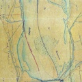
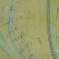
: Extrait du plan général du cours du Rhône indiquant le tracé des ouvrages projetés contre ce fleuve dans le territoire de Cruas. English title: Extract of the general plan of the Rhône river indicating the route of the works planned against this river at Cruas.")
Original title (in French): Extrait du plan général du cours du Rhône indiquant le tracé des ouvrages projetés contre ce fleuve dans le territoire de Cruas. English title: Extract of the general plan of the Rhône river indicating the route of the works planned against this river at Cruas.
- Auteur
- Josserand
- Tags
- Fonds/Photographic fund
- Archives Nationales (France) (reference: F/14/6518)
- Contributeurs/Contributors
- Nature de la ressource/Resource type
- Map
- Date
- Période/Period
- 1844
- Commune/Municipality
- Secteur/Sector
- Cruas (4 km long)
- Echelle/Scale
- 1/10 000
- Lieu visé ou point de visée/Targeted place or photographer geolocation
- Projet OHM/OHM project
- Complément d'information/Additional information
- Ressource liée/Linked resource
- DOI
- Copyright
- Creative Commons (BY-NC)
- Make
- Canon
- Model
- Canon PowerShot G9
- DateTimeOriginal
- 2018:04:12 04:35:59
- ApertureFNumber
- f/4.0