
164/350
)
)
)
)
)
)
)
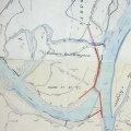
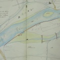
: Plan de la rive gauche du Rhône aux abords des brêches faites au chemin de halage et à la chaussée insubmersible de Boulbon par l'inondation du 4 novembre 1840. English title: Map of the left bank of the Rhône river near the breaches made to the towpath and the Boulbon unsubmersible roadway by the flood of 4 November 1840.")
Original title (in French): Plan de la rive gauche du Rhône aux abords des brêches faites au chemin de halage et à la chaussée insubmersible de Boulbon par l'inondation du 4 novembre 1840. English title: Map of the left bank of the Rhône river near the breaches made to the towpath and the Boulbon unsubmersible roadway by the flood of 4 November 1840.
- Auteur
- Ponts & Chaussées
- Tags
- Fonds/Photographic fund
- Archives Nationales (France) (reference: F/14/6537)
- Contributeurs/Contributors
- Nature de la ressource/Resource type
- Map
- Date
- Période/Period
- 1845
- Commune/Municipality
- Secteur/Sector
- Boulbon (1 km long)
- Echelle/Scale
- 1/2500
- Lieu visé ou point de visée/Targeted place or photographer geolocation
- Projet OHM/OHM project
- Complément d'information/Additional information
- Ressource liée/Linked resource
- DOI
- Copyright
- Creative Commons (BY-NC)