
161/350
)
)
)
)
)
)
)
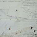
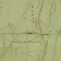
: Plan d'une partie du cours du Rhône dans le territoire de Roquemaure avec l'ancien cours en 1780 marqué en jaune. English title: Map of part of the Rhône river at Roquemaure with the old river course in 1780 marked in yellow.")
Original title (in French): Plan d'une partie du cours du Rhône dans le territoire de Roquemaure avec l'ancien cours en 1780 marqué en jaune. English title: Map of part of the Rhône river at Roquemaure with the old river course in 1780 marked in yellow.
- Auteur
- Ponts & Chaussées
- Tags
- Fonds/Photographic fund
- Archives Nationales (France) (reference: F/14/6589)
- Contributeurs/Contributors
- Nature de la ressource/Resource type
- Map
- Date
- Période/Period
- 1828
- Commune/Municipality
- Secteur/Sector
- Roquemaure (5 km long)
- Echelle/Scale
- 1/5000
- Lieu visé ou point de visée/Targeted place or photographer geolocation
- Projet OHM/OHM project
- Complément d'information/Additional information
- Ressource liée/Linked resource
- DOI
- Copyright
- Creative Commons (BY-NC)