
237/350
)
)
)
)
)
)
)
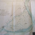
: Plan général d'une partie de la rivière de Payre indiquant le projet de digue à construire sur le territoire de la commune du Pouzin. English title: General plan of a part of the Payre river indicating the dyke project to be built at the town of Pouzin.")
Original title (in French): Plan général d'une partie de la rivière de Payre indiquant le projet de digue à construire sur le territoire de la commune du Pouzin. English title: General plan of a part of the Payre river indicating the dyke project to be built at the town of Pouzin.
- Auteur
- Ponts & Chaussées
- Tags
- Fonds/Photographic fund
- Archives Nationales (France) (reference: F/14/6517 )
- Contributeurs/Contributors
- Nature de la ressource/Resource type
- Map
- Date
- Période/Period
- 1847
- Commune/Municipality
- Secteur/Sector
- Le Pouzin (5 km long)
- Echelle/Scale
- 1/10 000
- Lieu visé ou point de visée/Targeted place or photographer geolocation
- Projet OHM/OHM project
- Complément d'information/Additional information
- Ressource liée/Linked resource
- DOI
- Copyright
- Creative Commons (BY-NC)