
234/350
)
)
)
)
)
)
)
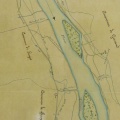
: Classement des terrains intéressés à la construction d'une digue en amont du pont du Theil, dite digue de Chambeyrol. English title: Classification of lands relevant to the construction of a dyke upstream of the Theil bridge, known as the Chambeyrol dyke.")
Original title (in French): Classement des terrains intéressés à la construction d'une digue en amont du pont du Theil, dite digue de Chambeyrol. English title: Classification of lands relevant to the construction of a dyke upstream of the Theil bridge, known as the Chambeyrol dyke.
- Auteur
- Tavernier
- Tags
- Fonds/Photographic fund
- Archives Nationales (France) (reference: F/14/6518)
- Contributeurs/Contributors
- Nature de la ressource/Resource type
- Map
- Date
- Période/Period
- 1868
- Commune/Municipality
- Secteur/Sector
- Le Teil (3 km long)
- Echelle/Scale
- 1/5000
- Lieu visé ou point de visée/Targeted place or photographer geolocation
- Projet OHM/OHM project
- Complément d'information/Additional information
- Ressource liée/Linked resource
- DOI
- Copyright
- Creative Commons (BY-NC)