
Accueil / OHM Vallée du Rhône / Archives cartographiques et topographiques /
Map/Cross section (Lyon, 1855)
215/350
)
)
)
)
)
)
)
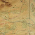
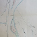
: Endiguement de la rive gauche du Rhône entre l'extrémité aval de la digue de la Vitriolerie et un point situé sur la digue de St Fons, au droit de la maison Bourdin, dans les communes de Lyon et de Vénissieux, sur une longueur totale de 4297,92 m. English title: Impoundment of the left bank of the Rhône river between the downstream end of the Vitriolerie dyke and a point on the St Fons dyke, at the Bourdin house, in the cities of Lyon and Vénissieux, over a length of 4297.92 m.")
Original title (in French): Endiguement de la rive gauche du Rhône entre l'extrémité aval de la digue de la Vitriolerie et un point situé sur la digue de St Fons, au droit de la maison Bourdin, dans les communes de Lyon et de Vénissieux, sur une longueur totale de 4297,92 m. English title: Impoundment of the left bank of the Rhône river between the downstream end of the Vitriolerie dyke and a point on the St Fons dyke, at the Bourdin house, in the cities of Lyon and Vénissieux, over a length of 4297.92 m.
- Auteur
- Kleitz
- Tags
- Fonds/Photographic fund
- Archives Départementales du Rhône (reference: S 1363)
- Contributeurs/Contributors
- Nature de la ressource/Resource type
- Map/Cross section
- Date
- Période/Period
- 1855
- Commune/Municipality
- Secteur/Sector
- Lyon (8,5 km long)
- Echelle/Scale
- 1/5000
- Lieu visé ou point de visée/Targeted place or photographer geolocation
- Projet OHM/OHM project
- Complément d'information/Additional information
- Ressource liée/Linked resource
- DOI
- Copyright
- Creative Commons (BY-NC)