
Inicio / OHM Vallée du Rhône / Archives cartographiques et topographiques /
Map/Cross section/Long profile (Virignin, 1866-1870)
323/350
)
)
)
)
)
)
)
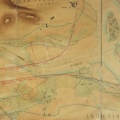
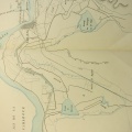
: Amélioration de la navigation au passage de St Blaise. English title: Navigation improvement at the passage through St Blaise.")
Original title (in French): Amélioration de la navigation au passage de St Blaise. English title: Navigation improvement at the passage through St Blaise.
- Autor
- Tavernier
- Tags
- Fonds/Photographic fund
- Archives Départementales du Rhône (reference: S 1358)
- Contributeurs/Contributors
- Nature de la ressource/Resource type
- Map/Cross section/Long profile
- Date
- Période/Period
- 1866-1870
- Commune/Municipality
- Secteur/Sector
- Virignin (2,5 km long)
- Echelle/Scale
- 1/5000
- Lieu visé ou point de visée/Targeted place or photographer geolocation
- Projet OHM/OHM project
- Complément d'information/Additional information
- 3 maps, 8 cross sections, 1 long profile
- Ressource liée/Linked resource
- DOI
- Copyright
- Creative Commons (BY-NC)
- Make
- Canon
- Model
- Canon PowerShot S110
- DateTimeOriginal
- 2020:01:30 11:26:36
- ApertureFNumber
- f/2.0