
Accueil / OHM Vallée du Rhône / Archives cartographiques et topographiques /
Map/LongProfile/Cross section (Tournon, 1854-1856)
200/350
)
)
)
)
)
)
)
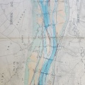
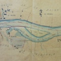
: Amélioration du chenal en aval de Tournon. English title: Channel improvement downstream of Tournon.")
Original title (in French): Amélioration du chenal en aval de Tournon. English title: Channel improvement downstream of Tournon.
- Auteur
- Tavernier
- Tags
- Fonds/Photographic fund
- Archives Départementales du Rhône (reference: S 1410)
- Contributeurs/Contributors
- Nature de la ressource/Resource type
- Map/LongProfile/Cross section
- Date
- Période/Period
- 1854-1856
- Commune/Municipality
- Secteur/Sector
- Tournon (4 km long)
- Echelle/Scale
- 1/5000
- Lieu visé ou point de visée/Targeted place or photographer geolocation
- Projet OHM/OHM project
- Complément d'information/Additional information
- 2 maps, 1 long profile, 3 cross sections
- Ressource liée/Linked resource
- DOI
- Copyright
- Creative Commons (BY-NC)