
Accueil / OHM Vallée du Rhône / Archives cartographiques et topographiques /
Map/Cross section (Lyon, 1854)
40/350
)
)
)
)
)
)
)
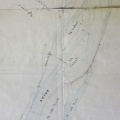
: Construction d'une digue insubmersible au confluent du Rhône et de la Saône, en aval du pont de la Mulatière et en prolongement de la presqu'Ile de Perrache, dans la commune de Ste Foy, sur une longueur de 420,00 m. English title: Construction of an unsubmersibe dyke at the Rhône and Saône confluence, downstream of the Mulatière bridge, and as an extension of the Perrache presqu'ile, on Ste Foy, over a length of 420.00 m.")
Original title (in French): Construction d'une digue insubmersible au confluent du Rhône et de la Saône, en aval du pont de la Mulatière et en prolongement de la presqu'Ile de Perrache, dans la commune de Ste Foy, sur une longueur de 420,00 m. English title: Construction of an unsubmersibe dyke at the Rhône and Saône confluence, downstream of the Mulatière bridge, and as an extension of the Perrache presqu'ile, on Ste Foy, over a length of 420.00 m.
- Auteur
- Tavernier
- Tags
- Fonds/Photographic fund
- Archives Départementales du Rhône (reference: S 1337)
- Contributeurs/Contributors
- Nature de la ressource/Resource type
- Map/Cross section
- Date
- Période/Period
- 1854
- Commune/Municipality
- Secteur/Sector
- Lyon (3 km long)
- Echelle/Scale
- ~ 1/2000
- Lieu visé ou point de visée/Targeted place or photographer geolocation
- Projet OHM/OHM project
- Complément d'information/Additional information
- Ressource liée/Linked resource
- DOI
- Copyright
- Creative Commons (BY-NC)