
Accueil / OHM Vallée du Rhône / Archives cartographiques et topographiques /
Map (Vérin to St-Pierre-de-Buf, 1842)
64/350
)
)
)
)
)
)
)
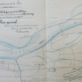
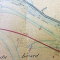
: Plan de la rive droite du Rhône dans le département de la Loire, joint au projet d'une digue de défense contre le Rhône entre la Valencize et le bac des Dames, sur une longueur de 1780,30 m. English title: Plan of the right bank of the Rhône river in the Loire department, attached to the project for a defensive dyke between the Valencize river and the Dames ferry, over a length of 1780.30 m.")
Original title (in French): Plan de la rive droite du Rhône dans le département de la Loire, joint au projet d'une digue de défense contre le Rhône entre la Valencize et le bac des Dames, sur une longueur de 1780,30 m. English title: Plan of the right bank of the Rhône river in the Loire department, attached to the project for a defensive dyke between the Valencize river and the Dames ferry, over a length of 1780.30 m.
- Auteur
- Barreau
- Tags
- Fonds/Photographic fund
- Archives Départementales du Rhône (reference: S 1393)
- Contributeurs/Contributors
- Nature de la ressource/Resource type
- Map
- Date
- Période/Period
- 1842
- Commune/Municipality
- Secteur/Sector
- Vérin to St-Pierre-de-Buf (10,5 km long)
- Echelle/Scale
- 1/10 000
- Lieu visé ou point de visée/Targeted place or photographer geolocation
- Projet OHM/OHM project
- Complément d'information/Additional information
- Ressource liée/Linked resource
- DOI
- Copyright
- Creative Commons (BY-NC)
- Make
- Canon
- Model
- Canon PowerShot S110
- DateTimeOriginal
- 2020:01:24 13:50:12
- ApertureFNumber
- f/2.0