
130/350
)
)
)
)
)
)
)
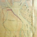
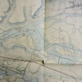
: Carte des brotteaux du Rhône entre Feyzin, Irigny et Pierre-Bénite. English title: Map of the brotteaux of the Rhône river between Feyzin, Irigny, and Pierre-Bénite.")
Original title (in French): Carte des brotteaux du Rhône entre Feyzin, Irigny et Pierre-Bénite. English title: Map of the brotteaux of the Rhône river between Feyzin, Irigny, and Pierre-Bénite.
- Author
- Maupin, Caderon?, Delahaye, NA
- Tags
- Fonds/Photographic fund
- Archives Départementales du Rhône (reference: 44 J 336, 44 J 337, 44 J 339)
- Contributeurs/Contributors
- Nature de la ressource/Resource type
- Map
- Date
- Période/Period
- 1642-1660
- Commune/Municipality
- Secteur/Sector
- Irigny (7 km long)
- Echelle/Scale
- ~ 1/10000
- Lieu visé ou point de visée/Targeted place or photographer geolocation
- Projet OHM/OHM project
- Complément d'information/Additional information
- 6 maps. Artist view but distances between villages are consistent with the present situation
- Ressource liée/Linked resource
- DOI
- Copyright
- Creative Commons (BY-NC)
- Make
- Canon
- Model
- Canon PowerShot S110
- DateTimeOriginal
- 2020:02:05 11:18:20
- ApertureFNumber
- f/2.0