
Accueil / OHM Vallée du Rhône / Archives cartographiques et topographiques /
Map (Villeurbanne, 1838)
266/350
)
)
)
)
)
)
)
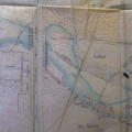
: Endiguement du fleuve du Rhône à l'amont de Lyon sur la rive gauche. English title: Impoundment of the left bank of the Rhône river upstream of Lyon.")
Original title (in French): Endiguement du fleuve du Rhône à l'amont de Lyon sur la rive gauche. English title: Impoundment of the left bank of the Rhône river upstream of Lyon.
- Auteur
- Ponts & Chaussées
- Tags
- Fonds/Photographic fund
- Archives Départementales du Rhône (reference: S 1360)
- Contributeurs/Contributors
- Nature de la ressource/Resource type
- Map
- Date
- Période/Period
- 1838
- Commune/Municipality
- Secteur/Sector
- Villeurbanne (5,5 km long)
- Echelle/Scale
- 1/2500
- Lieu visé ou point de visée/Targeted place or photographer geolocation
- Projet OHM/OHM project
- Complément d'information/Additional information
- Ressource liée/Linked resource
- DOI
- Copyright
- Creative Commons (BY-NC)
- Make
- Canon
- Model
- Canon PowerShot S110
- DateTimeOriginal
- 2020:01:24 11:56:26
- ApertureFNumber
- f/2.0