
Início / OHM Vallée du Rhône / Archives cartographiques et topographiques /
Map/Cross section/Long profile (Ain confluence to Lyon, 1847)
343/350
)
)
)
)
)
)
)
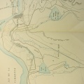
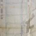
: Amélioration de la partie comprise entre l'embouchure de l'Ain et Lyon sur une longueur de 25 km. English title: Improvement of the reach between the Ain confluence and Lyon over a length of 25 km.")
Original title (in French): Amélioration de la partie comprise entre l'embouchure de l'Ain et Lyon sur une longueur de 25 km. English title: Improvement of the reach between the Ain confluence and Lyon over a length of 25 km.
- Autor
- O'Brien
- Tags
- Fonds/Photographic fund
- Archives Départementales du Rhône, Archives Nationales (France) (reference: S 1364, F/14/6502)
- Contributeurs/Contributors
- Nature de la ressource/Resource type
- Map/Cross section/Long profile
- Date
- Période/Period
- 1847
- Commune/Municipality
- Secteur/Sector
- Ain confluence to Lyon (34 km long)
- Echelle/Scale
- 1/10 000
- Lieu visé ou point de visée/Targeted place or photographer geolocation
- Projet OHM/OHM project
- Complément d'information/Additional information
- Deteriorated tracing paper. 2 maps and 1 long profile serie
- Ressource liée/Linked resource
- DOI
- Copyright
- Creative Commons (BY-NC)
- Make
- Canon
- Model
- Canon PowerShot S110
- DateTimeOriginal
- 2020:01:24 15:24:32
- ApertureFNumber
- f/2.2